Blog

Camping, backpacking and hiking

0

Camping, backpacking and hiking
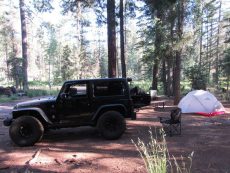
I decided I’m going to expand the range of topics in the blog beyond offroading. I really enjoy wheeling, the whole offroading culture and people I meet on jeep runs who share the same passion. Sometimes however I feel like driving my Jeep some place away from the crowd, far from the city where there’s no cell signal, get out of my vehicle, and enjoy nature more directly.
I’m talking camping, fishing, kayaking, hiking or backpacking. We are really fortunate to have so many beautiful places in Arizona, with forests, lakes and rivers that are worth visiting and truly enjoying. Enjoying responsibly.
Most places are easily accessible by car, but having an offroad-capable vehicle gives us a chance to discover some hidden gems.

We’re lucky because our vehicles can take us to places where others can’t go. We can venture deep into the back country, follow the trail for as long as we want and then set up camp. We can just relax and enjoy the spot, go on a backpacking trip or a day hike.

I’ve always enjoyed camping, backpacking and hiking. The outdoors in general. I recently decided to update my gear, trying to find a balance between good quality ultralight equipment and the price. I have been acquiring new gear over a period of several months and intend to keep doing it into the future. All this gear needs to be tested in the wild, so any chance I get, I head for the back country or at least the desert away from the city.
I am going to post short articles describing the locations I visit and my experience with the gear I selected.

GEAR
I am going to share my thoughts and opinions on all kinds of camping, backpacking and hiking gear I decided to purchase for myself. Some of the categories of gear will include: shelter, sleep systems, backpacks, cooking systems, water storage, water filtration and more.

 
CAMPGROUNDS
I will be sharing descriptions of the campgrounds I had a chance to visit. I will include directions to the site, description of the campsite and amenities, and include some photos of the site.

 
HIKING AND BACKPACKING
I will be describing trails I hiked, including directions to the trail head, description of the trail and photos. You really do not have to go far from the Valley of the Sun to find a great hiking trail.


July 21, 2017 |

Reservation Lake Campground

0

Location: South of Greer, Arizona.

Elevation: 9,050 feet

Season: April through November

Access: Gravel road

Fee: $9.00 per vehicle per night

Reservations: No reservations. Sites are available on a first-come, first-served basis.

Usage: Low / Medium

Days Limit: 14 days

Amenities: 60 camp sites, tent camping, trailer camping, no hookups, no potable water, picnic tables (at most campsites), rock fire rings, vault toilets, pets must be restrained or on a leash

Information: Pinetop Game & Fish Department (928) 367-4281, the Apache Sitgreaves National Forest at (928) 368-2100 www.fs.usda.gov/asnf or White Mountain Apache Tribe Game & Fish Department @ (928) 338-4385.


Greer, AZ WEATHER


Directions: From Show Low, take SR 260 east, 20 miles past the Hon-Dah Convenience Store to SR 273, turn right onto SR 273 and travel 14.3 miles to FR 116. Follow this graded gravel road for 11 miles to the entrance of the Reservation Lake recreational area.
(more…)

September 24, 2019 |

Horse Springs Campground

0

Location: West of Alpine, Arizona.

Elevation: 7,610 feet

Season: May through October

Access: Dirt road

Fee: $14.00 per camp unit per night

Reservations: No reservations. Sites are available on a first-come, first-served basis.

Usage: Medium / High

Days Limit: 14 days

Amenities: 27 single unit sites, tent camping, trailer camping, trailers and motorhomes up to 32 foot, no hookups, picnic tables (at each campsite), rock fire rings, potable water faucets, vault toilets, pets must be restrained or on a leash, concessionaire operated

Information: Alpine Ranger District, Apache-Sitgreaves National Forests, (928) 339-5000 or www.fs.usda.gov/asnf


Alpine, AZ WEATHER


Directions: From Alpine, drive two miles north on US Highway 191 to Forest Road 249 (Three Forks Rd). Turn west and follow this paved forest road 5 miles to Forest Road 276 (graded dirt road). Turn south and follow Forest Road 276 for 10.5 miles.
(more…)

May 26, 2019 |

Massacre Grounds hiking trail

0

Location: Apache Junction, Arizona

Difficulty Rating: Moderate

Route Type: Out & Back

Length: 5.0 miles round trip

Usage: Moderate

Trailhead Elevation: 2,117 ft.

Elevation Gain: 1,087 ft.

Park Fee: No fee

Trailhead Amenities: parking, trail map and information


Apache Junction WEATHER


Directions: From central Phoenix, take I-10 east to US 60 east. Exit on Idaho Road, follow Idaho Road north to N Apache Trail, bear right onto N Apache Trail and follow it 0.5 mile past the Lost Dutchman State Park entrance. Turn right onto N First Water Road. Follow this dirt road 0.5 mile where you’ll find a trailhead parking. Parking lot fits about 30 cars and there might be horse trailers used by guided horse tour groups.


(more…)
March 31, 2019 |

Moonlight Trail / San Tan Trail hiking loop

0

Location: San Tan Mountain Regional Park

Park Hours: Sun-Thu: 6am – 8pm / Fri-Sat: 6am – 10pm / 365 days a year

Difficulty Rating: Moderate

Route Type: Loop

Length: 3.5 miles

Usage: Moderate

Trailhead Elevation: 1,400 ft.

Elevation Gain: 131 ft.

Park Fee: $7.00 per vehicle

Trailhead Amenities: parking, visitor center, restrooms, gift shop, trail map and information

 
Queen Creek, AZ WEATHER

Directions: From central Phoenix, take I-10 east to US 60 east. Exit Ellsworth Road south to Hunt Highway. Travel east on Hunt Highway to Thompson Road south. Turn west on Phillips Road to the San Tan Mountain Regional Park entrance.


(more…)
March 16, 2019 |

Second Water hiking trail

0

Location: Apache Junction, Arizona

Difficulty Rating: Moderate

Route Type: Out & Back

Length: 7.0 miles round trip

Usage: Low

Trailhead Elevation: 2,258 ft.

Elevation Gain: -368 ft.

Park Fee: No fee

Trailhead Amenities: parking, restrooms (portable), trail map and information

 
Apache Junction WEATHER

 
Directions: From central Phoenix, take I-10 east to US 60 east. Exit on Idaho Road, follow Idaho Road north to N Apache Trail, bear right onto N Apache Trail and follow it 0.5 mile past the Lost Dutchman State Park entrance. Turn right onto N First Water Road. Follow this dirt road 2.5 miles all the way to the end where you’ll find a trailhead parking. Parking lot fits about 50 cars, but the overflow “horse lot”, about 0.5 mile back, will fit additional vehicles.


(more…)
August 16, 2018 |

Miners Needle Loop hiking trail

0

Location: Gold Canyon, Arizona

Difficulty Rating: Moderate

Route Type: Loop

Length: 9.0 miles

Usage: Moderate

Trailhead Elevation: 2,400 ft.

Elevation Gain: 800 ft.

Park Fee: No fee

Trailhead Amenities: parking, restrooms (portable), trail map and information

 
Gold Canyon, AZ WEATHER

 
Directions: From Phoenix take US 60 east all the way to Gold Canyon. Turn left on E Peralta Road. Follow E Peralta Road north east. After about a mile it turns into a dirt road. Follow the road for about 7 miles, all the way to the end where you’ll find the trailhead parking lot, with overflow parking lot 1/4 mile back.


(more…)
July 22, 2018 |

Hawley Lake Campground

0

Location: East of McNary, Arizona

Elevation: 8,170 feet

Season: All Year

Access: Paved road

Fee: $9.00 per vehicle per night

Reservations: No reservations. Sites are available on a first-come, first-served basis.

Usage: Medium

Days Limit: 10 days

Amenities: 100 single unit sites, tent camping, trailer camping, trailers and motorhomes up to 10 foot, no hookups, picnic tables (at most campsites), potable water faucets, vault toilets, pets must be restrained or on a leash

Information: Pinetop Game & Fish Department (928) 367-4281, the Apache Sitgreaves National Forest at (928) 368-2100 www.fs.usda.gov/asnf or White Mountain Apache Tribe Game & Fish Department


McNary, AZ WEATHER


Directions: From Show Low, Take SR 260 east 7 miles past McNary to SR 473 turn right and travel 9 miles to Hawley Lake Campground.
(more…)

July 14, 2018 |

Horseshoe Cienega Lake Campground

0

Location: East of McNary, Arizona.

Elevation: 8,225 feet

Season: May through October

Access: Dirt road

Fee: $9.00 per camp site per night

Reservations: No reservations. Sites are available on a first-come, first-served basis.

Usage: Medium

Days Limit: No

Amenities: 70 single unit sites, tent camping, trailer camping, trailers and motorhomes up to 10 foot, no hookups, picnic tables (at most campsites), potable water faucets, vault toilets, pets must be restrained or on a leash

Information: Pinetop Game & Fish Department (928) 367-4281, the Apache Sitgreaves National Forest at (928) 368-2100 www.fs.usda.gov/asnf or White Mountain Apache Tribe Game & Fish Department


McNary, AZ WEATHER


Directions: Travel east on State Route 260 nine miles east of McNary. Take a right at the lake entrance and the campground lies 1.3 miles away.
(more…)

July 14, 2018 |

Treasure Loop hiking trail

0

Location: Lost Dutchman State Park

Park Hours: Sunrise – 10:00 p.m. / Park is open year-round except Christmas Day

Difficulty Rating: Moderate

Route Type: Loop

Length: 2.5 miles

Usage: High

Trailhead Elevation: 2,080 ft.

Elevation Gain: 500 ft.

Park Fee: $7.00 per vehicle

Trailhead Amenities: parking, restrooms, trail map and information

 
Apache Junction WEATHER

 
Directions: From central Phoenix, take I-10 east to US 60 east. Exit on Idaho Road, follow Idaho Road north to N Apache Trail, bear right onto N Apache Trail and follow it to the Lost Dutchman State Park entrance.


(more…)
April 4, 2018 |

Wave Cave hiking trail

0

Location: Gold Canyon, Arizona

Difficulty Rating: Moderate/Difficult

Route Type: Out & Back

Length: 3.5 miles round trip

Usage: Moderate

Trailhead Elevation: 2,200 ft.

Elevation Gain: 990 ft.

Park Fee: Arizona State Land Department Recreational Permit and Parking Pass is required

Trailhead Amenities: parking only

 
Gold Canyon, AZ WEATHER

 
Directions: From Phoenix take US 60 east all the way to Gold Canyon. Turn left on E Peralta Road. Follow E Peralta Road north east. After about a mile it turns into a dirt road. Follow the road for about 6 miles, the small parking lot is on the west side of the road.


(more…)
February 11, 2018 |

Peralta hiking trail

0

Location: Gold Canyon, Arizona

Difficulty Rating: Moderate

Route Type: Out & Back

Length: 5.0 miles round trip

Usage: Moderate

Trailhead Elevation: 2,400 ft.

Elevation Gain: 1,380 ft.

Park Fee: No fee

Trailhead Amenities: parking, restrooms (portable), trail map and information

 
Gold Canyon, AZ WEATHER

 
Directions: From Phoenix take US 60 east all the way to Gold Canyon. Turn left on E Peralta Road. Follow E Peralta Road north east. After about a mile it turns into a dirt road. Follow the road for about 7 miles, all the way to the end where you’ll find the trailhead parking lot.


(more…)
December 3, 2017 |

MSR Hubba Hubba NX 2-Person Tent

0

MSR Hubba Hubba NX 2
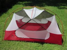
The MSR Hubba Hubba NX 2-Person Tent is a ultralight tent for three season backpacking. The NX stands for NEXT, the next generation of the Hubba series, as it has been redesigned for 2014. The three pounds and seven ounces of the Hubba Hubba NX is the lowest weight yet, as well as offering two different fast and light modes when combined with the optional footprint. Whatever it takes to give your back respite on the trail. The color coded webbing makes for a quick and easy set up so you can clamber inside to enjoy plenty of head and shoulder room due to the symmetrical pole geometry and non-tapered floor. The two large vestibules leave room for your gear and friend’s, with StayDry entry provided by built-in rain gutters on the rain fly. MSR added plenty of venting options to aid in the war against condensation, just roll up the vestibule from the bottom, open the kickstand side vents, or sleep through the night sans-vestibule. The mesh will protect you from pesky bugs. Rise early and pack up camp in a flash with the wide mouth stuff sack, cinching it tight with the attached compression straps.

The MSR Hubba Hubba NX is a great tent for two people. It’s incredibly easy to set up, lightweight, and has two doors so you can come and go at night without disturbing your partner. Nearly freestanding, the pole configuration creates an interior space that has near vertical walls, providing excellent interior space and livability. With a trail weight of three and a half pounds, the Hubba Hubba NX is lightweight enough for backpacking use when shared by two people, but on the heavy if used by one. Still, MSR has done a fine job designing this tent, which should definitely be on your short list if you’re looking to upgrade to a spacious and comfortable lightweight two person tent for backpacking and camping.
(more…)

October 29, 2017 |

Siphon Draw hiking trail

0

Location: Lost Dutchman State Park

Park Hours: Sunrise – 10:00 p.m. / Park is open year-round except Christmas Day

Difficulty Rating: Moderate / Difficult

Route Type: Out & Back

Length: 4.0 miles round trip

Usage: High

Trailhead Elevation: 2,080 ft.

Elevation Gain: 1020 ft.

Park Fee: $7.00 per vehicle

Trailhead Amenities: parking, restrooms, trail map and information

 
Apache Junction WEATHER

 
Directions: From central Phoenix, take I-10 east to US 60 east. Exit on Idaho Road, follow Idaho Road north to N Apache Trail, bear right onto N Apache Trail and follow it to the Lost Dutchman State Park entrance.


(more…)
September 15, 2017 |

Hieroglyphic hiking trail

0

Location: Gold Canyon, Arizona

Difficulty Rating: Easy / Moderate

Route Type: Out & Back

Length: 2.9 miles round trip

Usage: Moderate

Trailhead Elevation: 2,085 ft.

Elevation Gain: 561 ft.

Park Fee: No fee

Trailhead Amenities: parking, restrooms (portable), trail map and information

 
Gold Canyon, AZ WEATHER

 
Directions: From Phoenix take US 60 east all the way to Gold Canyon. Turn left on S Kings Ranch Road, follow S Kings Ranch Road north, turn right on E Baseline Avenue, turn left on S Mohican Road, turn left on E Valley View Drive, follow it north onto S White Tail, turn right on E Cloudview Avenue and follow it east all the way to the end where you’ll find the trailhead parking lot.


(more…)
September 12, 2017 |

Diamond Rock Campground

0

Location: West of Alpine, Arizona.

Elevation: 7,885 feet

Season: May through October

Access: Dirt road

Fee: $14.00 per camp unit per night

Reservations: No reservations. Sites are available on a first-come, first-served basis.

Usage: Medium

Days Limit: 14 days

Amenities: 12 single unit sites, tent camping, trailer camping, trailers and motorhomes up to 10 foot, no hookups, picnic tables (at each campsite), rock fire rings, water (large water tank near camp host), vault toilets, pets must be restrained or on a leash, concessionaire operated

Information: Alpine Ranger District, Apache-Sitgreaves National Forests, (928) 339-5000 or www.fs.usda.gov/asnf


Alpine, AZ WEATHER


Directions: From Alpine, drive two miles north on US Highway 191 to Forest Road 249 (Three Forks Rd). Turn west and follow this paved forest road 5 miles to Forest Road 276 (graded dirt road). Turn south and follow Forest Road 276 for six miles to the East Fork developed camping area.
(more…)

September 3, 2017 |

Portable Water Storage Containers

0

Water Storage Containers
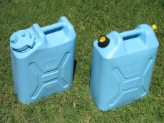
It might sound like a cliche, but water is life. Whether it’s for an emergency kit or a camping trip, having a supply of clean water is most important in any survival situation. As a general rule of thumb, you’ll need about one gallon of water per day, per person (and per pet!) in the event of an emergency. It is a good idea to always store at least one week worth of clean water in case of a disaster. Water sources can become disrupted or contaminated for prolonged periods and you’ll need water for both consumption, cooking, and hygiene purposes. Proper water storage is fairly simple if you have good water storage containers and know how to store them appropriately.
First of all, you need a water storage container that meets a number of safety requirements and viability tests. A container cannot be too heavy when full, needs to be durable, portable, puncture resistant, leak proof and meet food safety requirements. You also may or may not need it to be stackable, or to have a pouring spout or a spigot.
It is not recommended to use metal containers for long term water storage. The safest containers to hold water in are polyethylene-based plastics, or plastics #1, #2, and #4. These types are food-grade, BPA free, excellent for long-term storage and do not leach harmful chemicals into the water leaving a “plastic” taste.

The size of the water container you select depends on your needs. For short term storage you can use small containers (2-10L or in other words less than 3 gallons) and made out of soft collapsible plastic. If you plan to store more water for a longer period of time, you should pick a larger container made out of the most durable hard plastic material.

When you are deciding on water storage for camping or offroading trips, you need to select a container that is large enough to carry plenty of water (there might not be a clean water source the entire trip in some cases) and is durable enough to withstand the abuse in the backcountry.
Carrying a good water filtration system is also a good idea when you’re out in the wild.
(more…)

August 26, 2017 |

Choosing your backpacking tent

0

Choosing your backpacking tent
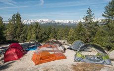
Determining which backpacking tent is the best for your adventures can be a difficult decision that is often influenced by your preferences. Where and when will you camp? How will you camp?
The three big items that affect your backpack weight are your pack itself, sleeping bag and your shelter. Investing in a lightweight tent can be one of the most cost-effective ways to reduce total pack weight.

There are many different types of tents out there, and choosing the right one will ensure a better camping experience. A tent, after all, is quite literally your “home away from home”.

Prices of backpacking tents vary, of course, although most high quality backpacking tents will cost between $100 – $500. Usually the more you spend the better the materials used. Materials that provide more strength and weigh less. There are few one person backpacking tents under $100 but around $200 is what you need to expect for high quality tents.
 
Choosing your backpacking tent involves the following key decision points:

Capacity: likely number of sleepers

Seasonality: tent construction relative to expected weather conditions

Weight: ounces carried vs. dollars spent

Livability: comfort and convenience based on design and features

Other considerations include ease of tent setup and tent materials. Also, don’t forget the footprint, often sold separately, that goes under your tent floor to protect it from routine wear or an overlooked rock or pine cone.
(more…)

August 24, 2017 |

Hannagan Meadow Campground

0

Location: South of Alpine, Arizona.

Elevation: 9,120 feet

Season: May through September

Access: Paved road

Fee: None

Reservations: No reservations. Sites are available on a first-come, first-served basis.

Usage: Medium

Days Limit: 14 days

Amenities: 8 single unit sites, trailers and motorhomes up to 16 foot, no hookups, picnic tables (at each campsite), vault toilets, water (potable water hydrants) – might not be available at all times, pets must be restrained or on a leash, campground host available May thru September, lodge and restaurant at nearby Hannagan Meadow

Information: Alpine Ranger District, Apache-Sitgreaves National Forests, (928) 339-5000 or www.fs.usda.gov/asnf


Alpine, AZ WEATHER


Directions: From Alpine, travel south on U.S. Route 191 for about 22 miles to Hannagan Meadow. The campground is 0.25 miles south of Hannagan Meadow Lodge on the west side of U.S. 191.
(more…)

August 20, 2017 |

Wind Cave hiking trail

0

Location: Usery Mountain Regional Park

Park Hours: Sun-Thu: 6am – 8pm / Fri-Sat: 6am – 10pm / 365 days a year

Difficulty Rating: Moderate

Route Type: Out & Back

Length: 3.0 miles round trip

Usage: High

Trailhead Elevation: 2,000 ft.

Elevation Gain: 812 ft.

Park Fee: $7.00 per vehicle

Trailhead Amenities: parking, restrooms, vending machines, trail map and information

 
Apache Junction WEATHER

 
Directions: From central Phoenix, take I-10 east to US 60 east. Exit Ellsworth Road, follow Ellsworth Road/Usery Pass Road north to the Usery Mountain Regional Park entrance.


(more…)
July 22, 2017 |
© 2024 AZoffroading.com - Arizona off-roaders' website. All Rights Reserved.