Check out these useful items


Daystar Hood Latch Upgrade Black Compatible with/Replacement for 2007-2018 Jeep Wrangler JK
Latest Blog Posts
- Jeep JK A/C Blend Door Actuator Replacement
- Jeep JK 3.6L V6 thermostat housing replacement
- My Jeep recovery gear
- Jeep JK 3.6L Pentastar Engine Oil Change
- Jeep JK Differential Fluid Change
- Jeep JK multi-function switch replacement
- Jeep Wrangler JK and JL Factory Bolt Sizes
- Jeep JK Jack Base by AEV
- Jeep JK Tailgate Tire Carrier by Rugged Ridge
- Jeep JK Dash A/C Vent Removal
Audiobook Recommendation

Location: Between Apache Junction and Theodore Roosevelt Lake.
Difficulty: Easy. First part paved, but mostly dirt. Blind curves and tight switchbacks near cliff edges require driver attention. The road is well marked and easy to follow. Carry plenty of drinking water.
Description: A 40 mile trail. First 18 miles from Lost Dutchman State Park is paved then it changes to well-maintained dirt road.
Time & Distance: Allow about 3 hours for this 40-mile trail. It’s a long drive back to Phoenix from Roosevelt Lake.
Trail Conditions: Tonto N.F., Mesa and Tonto Basin Ranger Districts. Call (480) 610-3300.
Remember: trail conditions, fire restrictions, weather, and land ownership change constantly so everyone must take responsibility for themselves, both for their safety and complying with all laws. Please understand that means YOU.
Directions to the Trail: From Phoenix take Highway 60 east to Apache Junction. Get off at Idaho Road, Exit 196, and head north. Turn right on Highway 88 and head northeast.
View Apache Trail in a larger map for even more DETAILS!
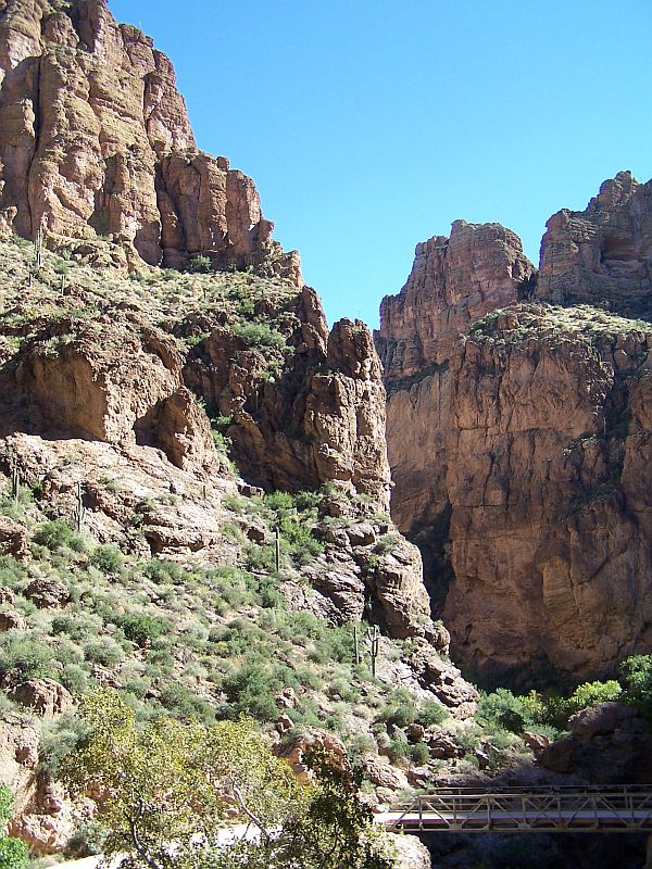 The road weaves along mountainsides above the Salt River Valley then drops suddenly into the valley at Fish Creek Hill. First about 18 miles is paved, and then the fun begins when it becomes a dirt road. You don’t get back on the pavement until just before Theodore Roosevelt Dam. Along the way you’re treated to great views of Canyon Lake and Apache Lake. Both man-made reservoirs offer a full array of water sports including boating, water skiing and fishing. The trail can get quite congested on weekends and holidays. There are few one-lane bridges along the way, so be courteous if you see someone coming from the other direction. South of Apache Trail is the vast Superstition Wilderness with an extensive network of hiking trails and backpacking opportunities. The road skirts the edge of the Salt River before climbing out of the valley at Theodore Roosevelt Dam which forms Roosevelt Lake. When full, the lake’s shoreline measures 112 miles. This vast recreation area has just about everything for the outdoor enthusiast. There are many great four-wheel-drive roads and trails in the surrounding Tonto National Forest.


Get yourself and your rig ready for the trip: Make sure both you and your vehicle are prepared for your next adventure.
Before you venture out on your offroading trip you need to make sure you are prepared for emergencies. Even if nothing happens to you or your vehicle, you might come across someone who needs help. Short of having your full-on bug-out-bag with you, you should at least have some basic emergency items. It might seem obvious to some, but you should get yourself a tool box with appropriate tools and leather gloves, good first aid kit, fire extinguisher, set of jumper cables, emergency blankets (stored in heavy plastic bag – both are useful), flashlight, tow strap and some extra water. I would also suggest a recovery strap, a military folding shovel, heavy duty garbage bags, and a hand crank self powered weather radio. These items are not expensive, but they just might save your day.
Another thing you should definitely do before you leave is to save the number to Arizona 4×4 Off Road Recovery in case you find yourself in need of recovery in the middle of nowhere. Their number is (602) 697-8306.
If you’re ready for a next adventure and want to plan it right, check out some of these trail guides – Arizona has so many awesome destinations to explore!

Arizona’s top-selling 4×4 guidebook. 100 of the best 4×4 trails in Arizona. Completely redone 3rd edition is more fun than ever. A new easy-open spiral binding features a wrap-around closure flap that doubles as a placeholder. Interior pages have been beefed up for extra durability.

